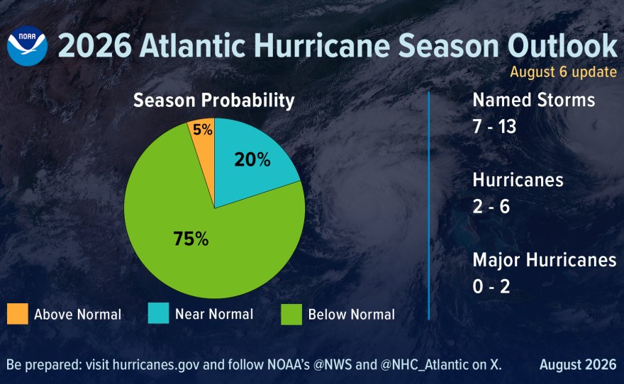
NOAA cut its 2026 Atlantic hurricane season forecast on Thursday, Aug. 6, projecting as few as seven named storms and no more than two major hurricanes as a rapidly strengthening El Niño suppresses storm development across the basin.
The revised outlook gives the season a 75% chance of finishing below normal, up from 55% when NOAA issued its initial forecast in May. That earlier outlook called for 8–14 named storms, 3–6 hurricanes and 1–3 major hurricanes. The new numbers: 7–13 named storms, 2–6 hurricanes and 0–2 major hurricanes.
For Palm Harbor and Dunedin residents, the quieter forecast does not equal an all-clear.
"Inland rainfall is a major cause of damage from tropical storms and hurricanes, as Arthur demonstrated," National Weather Service Director Ken Graham said in the NOAA announcement. "That's why it's important to prepare for every storm that's projected to impact your area, even if it never reaches hurricane strength."
El Niño running hotter than past 'super' events
El Niño was officially declared in June after Pacific sea surface temperatures crossed the threshold. Water temperatures in the El Niño zone now sit 2.07 degrees Celsius above average, higher than at the same point during the Super El Niño events of 2015, 1997, 1991 and 1982, Fox Weather reported.
Some NOAA computer models suggest this could become the strongest El Niño since record-keeping began in 1950.
Matt Rosencrans, NOAA's lead hurricane season forecaster, said El Niño has become the dominant factor in total season activity and continues to strengthen each month. El Niño increases wind shear over the Atlantic, disrupting developing tropical systems before they can organize. That shear, combined with dry air, has kept the basin quiet through the season's first two months. Only two named storms have formed so far: Tropical Storm Arthur in mid-June off the Texas coast and Tropical Storm Bertha, which made landfall in St. Bernard Parish, Louisiana. Neither reached hurricane strength.
Gulf 'homegrown' storms still a threat
Even with open-Atlantic formation largely shut down, forecasters warn that "homegrown" tropical systems can still develop in the northern Gulf of Mexico and along the Southeast coast, including near Florida. These storms tend to be weaker and shorter-lived but give residents less lead time before impacts arrive.
The climatological peak of hurricane season falls on Sept. 10, and more than 85% of tropical cyclone activity historically occurs from August through October. The strong El Niño seasons of 1982, 1997 and 2015 each still produced at least one major hurricane.
NOAA's seasonal outlook estimates basin-wide activity. It does not predict where storms will make landfall; those forecasts become possible only about a week before a potential strike.
Local preparedness resources
Pinellas County Emergency Management maintains evacuation zone maps, the 2026 Hurricane Guide and Alert Pinellas emergency notification sign-ups at disaster.pinellas.gov. The Pinellas County Sheriff's Office has compiled federal and county resources at PinellasSheriff.gov/Hurricane.
The season runs through Nov. 30, with 5–11 more named storms still possible before it ends.

.jpg)